23 April. Over the Easter break we took a trip to the Yorkshire Dales. Neither of us have ever spent any time in Yorkshire, we'd driven through innumerable times on our way to Newcastle and the 'North' so we thought it was about time we went to explore.
I've always had a yearning to visit Malham Cove and Gordale Scar so we found a very comfortable place to stay in the
Dales near to Settle - where the
Settle/Carlisle railway runs from - What a great little town (we saw Mike Harding, ooooh) and such a pretty little railway station, very much from a time gone by, with its flowers and tidy paint-work, very picturesque.
The view from our room, and how thoughtful, a table and chairs ready for us to enjoy a cheeky vimto after a long walk.
24 April, Easter Sunday. A classic walk by any standards and possibly the best limestone scenery in the dales. Under forget-me-not blue skies we followed a trail from Malham to Janet's Foss and Gordale Scar, up to Malham tarn and back down over Malham Cove, returning to the charming village of Malham for a restorative Shandy.
You can not tell from my photo just how
m. . .a. . .n. . .y people chose the same day as us to go for a stroll around Malham. Mind you an enterprising farmer opened one of his fields and for a small fee let everyone park for the day.
He had (possibly) up to 400 cars.
The woodland here probably existed before 1600 and is now owned by the National Trust. Luckily the Government can't sell this one . . .
The path to Janet's Foss.
Gordale beck flows from Gordale Scar, which on leaving the gorge runs on to become the small waterfall that is
Janet's Foss.
The old Norse for waterfall is foss, and Janet is a folk-tale reference to the queen of the local fairies, who inhabits a cave at the back of the fall.
Gordale Scar is a really dramatic limestone ravine about a miles gentle saunter from Malham village.
The gorge was formed by water from melting glaciers, it has two waterfalls and dramatic overhanging limestone cliffs more than 100m high, which cast a deliciously cool, pool of shade.
We had planned to follow the path up through the waterfalls, but as I watched grown men struggle to clamber over the boulders, I decided maybe it wasn't for me!
These clumps of little heartsease flowers are scattered liberally over the high meadows above Malham. Looking so delicate sitting in the rough grasses, however, looks can be deceiving because they must be pretty sturdy to weather the elements up here.
Bath with a view anyone?!
The land above (north) of Malham Cove is dotted with, Shake Holes, sheep, pot holes, people and very low windswept grasses without a tree to be seen.
It is a magnificent landscape of hills and stone walls.
This is the view from the limestone pavement at the top of the cove.
I'm not at all sure this photograph gives much sense of the scale of it all, it flattens things out a bit - BUT, I tell you - it felt like a long way up and there's no way I'd have stood there if it had been a windy day.
Malham Cove is the cove featured in the film, Harry Potter and the Deathly Hallows.
The large curved limestone cliff that is Malham Cove, with climbers for scale.
It made the hairs on the back of my neck stand on end just watching them. I guess that like a lot of us when we were young, they don't have much sense of their mortality.
The view of Malham Cove from about 6 miles away.
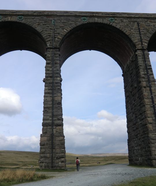
25 April, Easter Monday. A place I've wanted to visit for a long time. Ribblehead Viaduct. We followed the line of the railway to the aqueduct at Little Dale Beck where we branched off heading north via Smithy Hill, turning west towards Hagg Worm Haw, before turning south up to Whernside.
In shape Whernside forms a long ridge, running roughly north–south and is one of the Yorkshire Three Peaks, the other two being Ingleborough and Pen-y-Ghent. A reason to come back? . . . .
It's also the highest point in North Yorkshire.
Another day of pale blue skies with high cloud, the weather report had forecast rain, so, we did have everything with us bar the kitchen sink!
The aqueduct at Little Dale Beck.
Although we were in sunshine at the top of Whernside, the weather looked to be heading our way. 736m without shelter, yikes! Time to head down and south.
We approached Ribblehead viaduct from the valley floor in our own little patch of sunshine, which fortunately for us had accompanied us all day!
Looking impressive with its 24 massive stone and brick arches, 104' high and 440 yards long, it was built by navvies following a gentle curve across the valley.
Hundreds of navvies (including their wives and children) lost their lives building the line, from a combination of accidents, fights, and smallpox outbreaks.
In particular, building the Ribblehead (then Batty Moss) viaduct, caused such loss of life that the railway paid for an expansion of the local
graveyard.
There's always a pub at the end of our walk, this one has a weather station.
Tuesday 26 April. Fountains Abbey, a World Heritage Site.
Studley Royal, including the ruins of Fountains Abbey, became a World Heritage Site in 1986 for its outstanding 18th Century landscape, 12th Century Abbey, Elizabethan Fountains Hall and Victorian St Mary’s Church .
Water tap and socket, from the cloister c1170.
The magnificent Lay Brothers refectory (the west range), the monks would not have enjoyed this uninterrupted view, as the space was partitioned at that time.
The north aisle of the church, looking west.
Just look at the elegance of these high columns,
The Abbey, which is Britain's largest monastic ruin, was founded in 1132 by 13 Benedictine monks (exiled from St Mary's, York after a riot) seeking a simpler life.
Despite their spiritual zeal, the community was not viable and in their despair they turned to the Cistercian Order for help. In the autumn of 1135 they became Cistercian monks. By the middle of the 13th century, Fountains was one of the richest religious houses in Britain.
The south door to St Mary's church, designed by William Burges in the Victorian Gothic style, recognised as his religious masterpiece.
It has a highly decorated interior characteristic of the Anglo-Catholic religious sentiments of the period.
The choir stall are decorated with carved, painted parrots.
The sanctuary roof over the altar, is a vision of heaven, in full glorious Technicolor, with angels playing various musical instruments.
Wednesday 27 April. We stayed in Austwick just inside the Yorkshire Dales National Park, a pretty, unspoilt village surrounded by a pastoral landscape.
It's good walking country so we made up our minds to get a morning walk in, before we headed south for home. It was another day of powder blue skies and soft breezes. I think the local small gods of stone and hill have conspired to make us believe that Yorkshire is always like this, so that we'll pine to come back.
Austwick lies in the valley of Crummackdale, about 1/2 a mile wide and with high limestone scars on three sides.
The three Billy Goats Gruff. I know a story about those guys!
The path follows the ledge of rock at Nappa Scars.
These violets, looking so dainty, are everywhere in the meadows around Austwick Beck
A true green lane leads from the village of Wharfe up to Austwick Beck.
Earlier (up at Austwick Beck Head) we'd seen these yellow fields and wondered what was growing there. It looked like oil seed rape, but we didn't think it could be that because we hadn't seen any arable crops at all.
Turns out these are fields of dandelions, looking for all the world like fields of gold.
Pastoral England at its best, wouldn't you say
Austwick also has the friendliest pub we visited. We arrived at the Game Cock at about 2:40 ish and although the kitchen was closed, chef was in and took pity on us, and prepared us a hearty lunch. How good is that.